
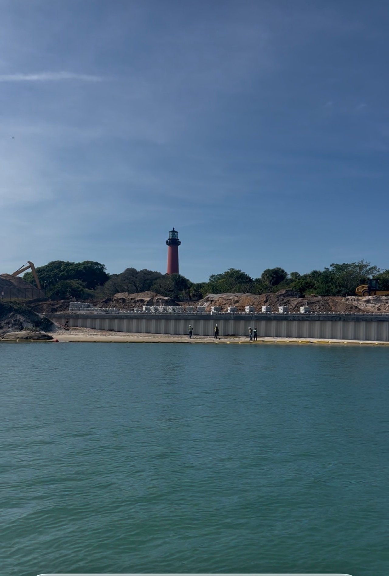
Walk the sandy bluff below the Jupiter Inlet Lighthouse this month and you'll see the shape of what's coming: a run of pilings driven into limestone, a curved retaining wall still raw from the pour, and a boardwalk taking form along roughly 830 feet of shoreline that erosion had been quietly eating away for decades. Most of what's been written about this project treats it as a story about erosion control and a new place to walk. That's true, but it's not the part of the project that will actually change how people use this water.
The federal agency overseeing the site has also redrawn where boats can anchor around the lighthouse, and that shift matters more to anyone who has ever pulled a boat up to that stretch of the Loxahatchee River than the boardwalk does.
As WFLX reported, the Bureau of Land Management is closing out an $16 million shoreline stabilization project across roughly five acres of the Jupiter Inlet Lighthouse Outstanding Natural Area, one of only three federally designated Outstanding Natural Areas in the country. Peter DeWitt, the BLM program manager overseeing the work, has been walking press and officials through the site as it wraps up.
Here's what's actually landing before winter:
Construction broke ground in 2025 with an original target of an August 2026 finish. The ribbon cutting is now scheduled for Dec. 3, a few months past that first estimate, which for a five-acre coastal construction project touching a National Register-adjacent landmark is a modest slip rather than a surprising one.
As WLRN reported, the boardwalk exists because an older fix wore out. Decades ago, one of the agencies managing this land poured concrete down the shoreline to hold it in place. DeWitt has said that solution worked for about 40 years before it started cracking, crevassing, and sliding into the waterway in pieces, which is a slower and messier failure than most people picture when they hear "erosion." The land had been losing roughly 7 feet of shoreline a year by the time the current project got underway.
The new approach leans on plantings and structure rather than a single concrete pour. Two hundred pilings now hold the boardwalk's limestone rock barrier in place. On the inlet's north side near Cato's Bridge, crews are installing about 100 feet of Seahive, a 3D-printed material developed at the University of Miami that forms concrete into hexagonal tubes stacked like a honeycomb, with a mangrove planter built into the back of each unit and space up front for oyster bags that recruit live oysters onto the structure. It's a shoreline that's designed to keep working after the ribbon gets cut, not just look finished on the day it does.
Here's the part that changes daily use of the water more than any boardwalk plank does. As part of the project, the BLM has established formal boating bays along the lagoon side of the lighthouse, replacing what had become an unregulated anchorage.
DeWitt has described the old pattern plainly: on the busiest weekends, 40 to 60 boats would anchor in that stretch, even though the site's actual daily use averaged only 17 boats. That gap between a slow Tuesday and a packed Saturday is exactly the kind of imbalance that erodes shorelines and frustrates the people trying to enjoy the water in between.
As WFLX reported, Jupiter resident Julia Ferguson, who was out with a group of paddleboarders when the boardwalk work was underway, said: "We're disappointed about it because it's a great place. But we also understand living here we have seen so much erosion of the sand up to the lighthouse, and so we knew it was a matter of time." That's not a rejection of the change, it's an acknowledgment of the tradeoff between anchoring there and preserving the shoreline.
If you've anchored near the lighthouse on a Saturday afternoon expecting to find your usual spot open, that expectation is worth revisiting once the bays are in full use. The capacity isn't gone. It's organized.
There's a second thread worth pulling here for anyone who has followed the town's long-running Riverwalk plan. The Town of Jupiter's own Riverwalk page has for years described its final, unbuilt phase as sitting along the southern shoreline of the Jupiter Inlet, directly across from the lighthouse, the same stretch of shoreline this federal project is now rebuilding. The town adopted its Riverwalk plan in 1998 and has built it out in phases since. The U.S. 1 bridge fully reopened in April 2025 after two years of construction.
The lighthouse boardwalk isn't officially a Riverwalk segment. It's a separate federal erosion project with its own funding and its own agency. But it occupies the same geography the town has earmarked for years, and once it opens, walkers and cyclists moving north along the existing trail will find a finished, walkable edge exactly where the Riverwalk's own plans have long shown a gap. Whether the town eventually ties the two together on a map is a separate question. On the ground this winter, the practical effect is the same: a stretch of shoreline that's been unfinished business for a long time is finally walkable.
For paddlers, anglers, and boaters who treat this stretch of the Loxahatchee as familiar water, the practical takeaways are straightforward. The new boarding areas and staircases open up shoreline access that wasn't there before, in a more structured way than the old scramble down eroded sand. The anchorage bays mean showing up on a Saturday with an assumption of open water near the lighthouse is no longer a safe bet. And the Seahive installation near Cato's Bridge is worth a slow pass by boat once it's in the water, since it's a rare chance to watch a University of Miami-designed reef structure recruit oysters in real time along a working shoreline.
None of this requires waiting for the Dec. 3 ribbon cutting to see for yourself. Much of the boardwalk and plantings are already visible from the existing Riverwalk path and from the water, and the construction fencing has been coming down in sections as crews finish each piece.
Jupiter's waterfront keeps changing shape a little at a time, and the lighthouse project is one more piece of that. If you're trying to understand how a specific stretch of shoreline, dock, or anchorage fits into what's happening around it, Malloy Home Team spends enough time on this water to talk it through with you.
This article is general information, not legal, tax or financial advice. Consult a qualified professional about your situation.


In a market where presentation, strategy, and relationships define outcomes, choosing the right team isn’t optional, it’s everything. At the Malloy Home Team at SERHANT., we don’t just list homes. We position them. We don’t just find properties. We secure opportunities others never see.

114 N Coastal Way Jupiter, FL 33477